
|
|
|
|
|
|
|
|
|
|
|
|
|
|
|
|
|
|
|
|
|
|
|
|

|
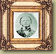
ANDREW CAULFIELD ANDERSON, HUDSON'S BAY COMPANY
Born in 1814, Alexander Caulfield Anderson was appointed an apprentice clerk for the Hudson's bay Company in 1831. He worked for the Company in various forts from 1831 to 1858, eventually becoming Chief factor at Fort Colville and second in command at fort Vancouver. During the 1840's, Anderson spent much of his time exploring and surveying possible all-British brigade trail routes from the Okanagan to the Pacific Coast. He created numerous early survey maps of British Columbia, now contained in the Provincial Archives. In the 1860's, he became the postmaster in Victoria. In 1876, he acted as Commissioner for settlement of the Indian land question in B.C. He died in Victoria in 1884.
New Trading Route
On May 22nd, 1847, Anderson started on foot along the difficult path leading downstream through the Thompson River canyon to the confluence of the Fraser and the Thompson River. From here they were led by Pahallak, a First Nations Guide from around Fort Yale, south through the Fraser Canyon. On the evening of May 25th, after a long hot day and 28 miles along the difficult trial, the party was mid-way through the canyon. Anderson wrote:
May 25th, the party broke camp at 3 a.m. hiking down the Fraser canyon to reach the mouth of Squazowm (Anderson) River. By following this river south, they by-passed the worst stretch of the Fraser canyon, re-joining the Fraser at Kequeloose (a mile above the old Alexandra Suspension Bridge). Three miles further down (near Spuzzum), they crossed the Fraser at a point Anderson thought a brigade could ferry or swim across easily. Continuing south, they walked downstream emerging from the canyon at "The foot of the rapids", around Lady Franklin rock just north of Yale. From here the Fraser was navigable. Anderson's party paddled the rest of the way to fort Langley by canoe - a swift and easy journey after the difficult hiking of the Fraser Canyon.
In 1848 the Hudson's bay fur brigades from fort Kamloops, fort Colville and the new Caledonia district made their way along Anderson's Brigade trail - then called the hope trial - to bring their furs to the shipping depot at fort Langley.
Andrew Caulfield Anderson and a party of five men started from Kamloops on May 19th, 1846 along a well known Hudson's bay company trail to 'Lac de Nicholas' (Nicola Lake) and on to the Thompson River at the site of present day Spences Bridge. They were searching for an all-British route for the brigades to deliver their winter's pelts from the inland mountain forts to the shipping points of Fort Langley of Fort Victoria.
"though I do not condemn these passages as impassable with horses, in the strict acceptation of that term, I decidedly think them quite impracticable for a loaded brigade, or loaded horses, however limited in number..."
The Construction of Fort Yale
Upon reaching the Fraser again, the brigade then struggled to swim or raft the 400 horses and their loads of pelts across the rushing waters of spring run-off on the Fraser River. Exhausted men and animals struggled the last few miles from miles what is now Spuzzum down to their rest station - a log building at Fort Yale. From Yale it was a short river ride to the green pastures and verdunt landscape of Fort Langley where the cargo was unloaded and the men and horses could make ready for the return journey. The return journey was equally as difficult, leading one of the hardy voyageurs, unable to endure any longer, to commit suicide.
Manson reported that on this trip he lost 70 horses and 25 pieces of cargo and that "...I have no hesitation in declaring it utterly impracticable for a large brigade such as ours". Anderson agreed and recommended that..." immediate measures for ascertaining the practicability of certain improvements and partial alterations in my route by the Simikameen of 1846, which have been suggested by Old Blackeye (a First Nations guide) and others...
By 1847, British American relations in Washington territory had closed the old Okanagan-Columbia River fur bridge trail to Hudson's bay Company travels. The 1848 fur brigade had to use the Fraser Canyon route Anderson had surveyed on foot the year before. Improvements were made along the route and a single log building was constructed as a way station for the brigades and given the name "Fort Yale" -after James Murray Yale, Chief Factor at Fort Langley.
The three brigades from New Caledonia, Fort Kamloops and Fort Colville under the command of Chief Trader Donald Manson left fort Kamloops in June 1848. A.C. Anderson was their guide. After an arduous journey, particularly between Anderson River and the Fraser where Manson wrote:
"The rugged, rocky, mountainous and thickly wooded country which lies between Fraser River and the plains, say a distance of about 43 miles, and which the brigade took ten days to pass, seven of which the horses were without food, is in my opinion, sufficient in itself to condemn this route" (Quoted by Morice, history of northern interior of B.C., p. 254)
The First Highway in B.C.
During the Goldrush year of 1858, on July 25th, a steamboat the Umatilla departed Fort Langley carrying 80 miners for a run up the Harrison River and Harrison Lake. The miners then hiked overland to Seton lake, following this water route north through Anderson lake to Lilloet. In August, Douglas appointed Anderson to oversee the construction of a mule trail 4 feet wide along the portages between the lakes of the Harrison Lilloet route. Douglas hired 100's of unemployed miners to build the Road paying their transportation (part way to the gold fields), equipment and food only - they provided their labour free of charge. In December, 1858, the Victoria Gazette printed that goods could now be taken from Port Douglas at the head of Harrison Lake to Lilloet at a cost of 18 cents a pound compared to the Fraser Canyon trails where charges of 46-47 cents per pound were levied between Yale to Lytton.
The Harrison-Lilloet road - the first highway in British Columbia - was constructed along the route Anderson had discovered 14 years previously while searching for fur brigade trails for the Hudson's Bay Company.
Harrison- Lilloet
The year prior to the 1847 Fraser canyon Expedition A.C. Anderson had discovered a route from Fort Langley by Seton and Anderson lakes connecting with the upper Fraser at what is now Lilloet.
Home| Contents| Tour| People| Collection| Transportation| Just For Kids!| Team
|
Last updated 31 August 1998. This digital collection was produced under contract to the SchoolNet Digital Collections Program, Industry Canada. Produced by Schoolnet Digital Collections Team. |

|